45 let od katastrofy pod Huascaranem
45 LET OD KATASTROFY POD HUSCARANEM
Otto Horský
Sedím v kině Roma v Limě a pozoruji odvíjející se děj filmu „Zemětřesení“. Náhle slyším dunění a pružná vlna poprvé rozechvívá sál. Milenci na filmovém plátně nevěnují drnčení oken a řinčení skla pozornost. Zato celým sálem kina proběhla první vlna vzrušení a mnozí, kteří tak důvěrně znají účinky zemětřesení, sklouzávají jako na povel se židlí a v bezmezném zmatku se plazí po zemi nebo prchají ze sálu. Ale film pokračuje dál. Většina diváků se po chvíli vracejí na svá místa a jen s námahou se snaží vstřebat přesvědčivost filmového ztvárnění otřesů. V zápětí se ve filmu otevírá geologický zlom a v něm mizí dva geologové měřící seizmickou aktivitu. Sál kina a lidé v něm se znovu rozechvívají pružnými vlnami, které umožňuje nová trojrozměrná technika zvuku. Chvějí se stěny, již již se bortí, diváci poskakují na svých židlích, všichni strnulí bezmeznou hrůzou. Dojem je naprosto dokonalý, neboť jsme v zemi, kde lidé neblahé účinky této metly lidstva již vícekrát zažili. Díky těmto zkušeným a impulzivním divákům jsem prožil filmové představení doplněné o autentické ukázky krizového chování. Do Limy jsem přiletěl začátkem prosince roku 1974 a diváci ještě měli v živé paměti hrůzy nedávného zemětřesení, které postihlo hlavně toto město.
Dne 31 května roku 1970 postihlo Peru mohutné zemětřesení o síle 7,5 stupně Richterovy stupnice. Otřesy způsobily uvolnění laviny ledu a kamení ze severní stěny Huascaranu, která se sesunula o 2500 m níže a svým pravým okrajem pohřbila základní tábor československé horolezecké expedice. Všech 14 členů výpravy společně s chilským průvodcem zahynulo.
Toto zemětřesení o síle 7 až 9 stupňů Richterovy stupnice patří svojí obrovskou intenzitou, ale i počtem mrtvých, mezi největší zaznamenaná zemětřesení nejen v historii Peru, ale na celé západní polokouli. Zasažená oblast přesahovala od pobřeží Pacifiku až do pohoří Kordiller délku 1000 km a šířku 250 km, zpustošena byla oblast o rozloze 83 500 km2. Zcela nebo téměř zaniklo 250 měst a obcí, zahynulo asi 80 000 lidí, 20 000 zůstalo nezvěstných, dalších 50 000 bylo vážně zraněno, v nemocnicích bylo hospitalizováno 143 331 zraněných, bez přístřeší zůstalo 200 000 lidí, nějak postižených bylo dle odhadů až 3 miliony lidí. Epicentrum zemětřesení se nacházelo v moři 30 km západně od přístavního města Chimbote. V samotném Chimbote dosahovalo magnitudo zemětřesení M až VIII stupně, ve starobylém městě Casma dokonce IX stupně. Síla zemětřesení byla tak mohutná, že vyvolala celou řadu sesuvů v okruhu přesahujícím 100 km kolem města Chimbote a na pobřeží Pacifického oceánu, ale zejména v pohoří ve správní oblasti Ancash a v provinciích Huánuco a La Libertad. Téměř třetina všech obětí katastrofy zahynula v oblasti nejvyšší peruánské hory, Huascaranu, z něhož se utrhla mocná lavina, která zasáhla hustě obydlené oblasti. Následné svahové pohyby se zde zkombinovaly a způsobily velké ztráty.
Katastrofa neblaze postihla naší horolezeckou výpravu. Byl vlhký, podzimní den, 31 května 1970, podobný jako každý rok v tuto dobu. V Limě v Peru bylo zataženo, na město padala „garrúa“, jak obyvatelé nazývají husté mžení, typické pro podzimní dny. Správní oblasti Ancash a La Libertad odpočívaly v klidné odpolední pohodě. Tam někde vysoko pod nejvyšší peruánskou horou Huascaran (6768 m n.m.) se chystala čtrnáctičlenná československá horolezecká expedice k výstupu. Právě byli shromážděni všichni v základním táboře a domlouvali se na podrobnostech a úkolech jednotlivých členů výpravy. A pak se to přihodilo. Bylo právě 15.36 hodin. Nikdo to nečekal. Obrovský otřes země o síle VII0 intenzity dle stupnice MCS trval 45 vteřin. Těchto 45 vteřin zmařilo tisíce lidských životů. Desetiletí lidského úsilí se rázem proměnilo v trosky a škody byly nedozírné. Ze 38 měst a vesnic v regionu Ancash 15 bylo totálně zničeno a zbytek byl povážlivě poškozen. Více než 70 000 domů bylo klasifikováno jako neobyvatelných, byly zničeny přivaděče vody, kanalizace, byla omezena výroba elektrické energie na pouhých 10% normálního výkonu v hydrocentrále „Caňol del Pato“ na řece Santa v provincii Huallanca a hydrocentrála byla vážně poškozena. Beze všech pochybností, tato správní oblast byla nejvíce postižena a v ní zejména malebná oblast Callejon de Huaylas pod Huascaranem. Město Huaráz bylo po zemětřesení pokryto černým kobercem prachu a zůstalo v něm 10 000 mrtvých. Také další města a vesnice v této oblasti byla totálně zničena, od Recuay na jihu až po město Huallanca na severu. Druhé nejvýznamnější město Yungay, společně s osadou Ranrahirkou, byly pohřbeny pod lavinou bahna a kamení, pod níž zůstalo 25 000 obyvatel a celá československá horolezecká expedice. Laviny a sesuvy půdy přerušily cesty a silnice, v několika místech zatarasily tok řeky Santa a zmizela železnice spojující město Chimbote s Huallankou.
Se smutkem vzpomínáme na tuto tragickou přírodní katastrofu. Je všeobecně známo, že severní vrchol Huascaranu v Bílých Kordillerách patři k masivům, které stojí na nepevných nohou. Již v minulosti se z této hory zřítily ničivé laviny kamení a rozbředlého materiálu a zničily osadu Ranrahirca. V roce 1962 zahynuly v této osadě a v jejím okolí čtyři tisíce lidí. Severní vrchol již několikrát v novodobé historii dokazoval svůj neklid. Snad žádná jiná hora v této oblasti tak často nesetřásá svůj mohutný ledový příkrov.
„Po ohlušujícím rachotu se vždy utrhne a zřítí několik bloků skály a ledu, které při svém pádu strhnou další materiál a vyvolají rozsáhlé sesuvy ledu, sněhu a skal a proletí Huaylskou soutěskou, „Callejon de Huayalas“, úzkým kaňonem podél řeky Santa.“
Bohužel, právě v době, kdy pod Huascaranem tábořila výprava československých horolezců, postihlo Peru snad jedno z největších zemětřesení v novodobé historii. Takovému náporu nemohl nesoudržný Huascaran odolat. Po prvním větším záchvěvu země se odlomil až devadesát metrů tlustý a dva kilometry široký blok ledu a sněhu, který se zřítil po osm set metrů vysoké skalní stěně. Přitom s sebou strhl nesmírné množství skalních bloků a sutí. Lavina proletěla po jednom z ledovců, protrhla postranní morény a dole se natlačila do kaňonu Rio Shacsha. Příval měl takovou kinetickou energii, že ještě na horním konci kaňonu přeletěl jeho postranní proud horský hřeben, jakoby byl katapultován, a pak se sesunul na město Yungay. Hlavní proud laviny se hnal dolů údolím řeky Shacsha, smetl Ranrahirku a valil se pak dál údolím řeky Santa, kde na celém toku dokončil dílo zkázy. K představě, o jak výjimečný sesuv šlo, snad přispěje údaj, že až do údolí Shacsha í dál přinesl skalní bloky veliké jako panelový dům. Rychlost sesuvu byla v souladu s fyzikálními zákony. Od místa odtrhnutí hmot až k soutoku zmíněných řek je to patnáct kilometrů. Hlavní masa sesuvu urazila tuto vzdálenost asi za dvě minuty, což odpovídá rychlosti až 450 kilometrů v hodině. Samozřejmě, že při takové rychlosti měl ničivé účinky í stále stlačovaný polštář vzduchu před lavinou, jejíž objem se odhaduje na padesát miliónů kubických metrů hmoty. Pod obrovskou masou sněhu, ledu, bláta a kamení nalezlo smrt i čtrnáct československých horolezců. Město Yungay přestalo existovat.
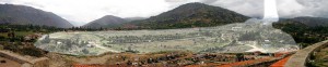
Yungay (2500 m), pohled z vrcholku od místního hřbitova. Označená oblast ukazuje rozsah laviny sněhu, ledu a kamení, které pohřbilo město po zemětřesení.
http://commons.wikimedia.org/wiki/File: Yungay_Viejo_location_of_landslide_1970
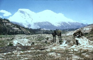
Severní vrchol Huascaranu, s jasně viditelnou odlučnou hranou, odkud se utrhla lavina skal, ledu a kamení, která zničila město Yungay a obec Ranrahirca. Foto M. Knejzlík, 1978.
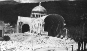
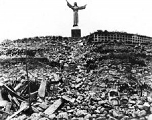
Kostel v městě Yungay po zemětřesení. Níže socha Krista nad místním hřbitovem. La Revista de Hoy, 1970.
Při vzpomínce na tuto událost vyvstává otázka, zda si naši horolezci správně vybrali svoji základnu, v níž se připravovali na výstup. Určitě ano. Ostatně, její umístění konzultovali s peruánskými andinisty a dalšími odborníky. Ale kdo mohl počítat s tím, že utržená masa hory Huascaranu bude tak obrovská a živá, že se převalí přes údolí a přes protilehlý hřeben a zasype naše horolezce? Asi dva kilometry výše ve svahu byl tábor japonských horolezců, kteří celou tragedii pozorovali a je lavina minula.
Po zemětřesení přizvala peruánská vládu k posouzení katastrofy celou řadu mezinárodně uznávaných expertů. Mezi nimi také jednoho z nejuznávanějších světových odborníků z oboru mechaniky hornin, profesora Vojtěch Mencla z Vysokého učení technického v Brně. Ten posuzoval zejména příčiny vzniku a charakter sesuvu. Podle něj se západní část vrcholu hory Nevados Huascaran zřítila na ledovec, čímž vznikla ohromná lavina kamení, sněhu a le-du, která vytvořila suťový proud dlouhý 16 km, při čemž sesuvné hmoty dosahovaly objemu 50 – 100 mil. m3. Rychlost pohybu skalních sutí byla odhadována na 280 km/h, místy i více. Část pohybu se děla po vzdušném polštáři (Mencl 1974). V údolí řeky Santy došlo k promísení tohoto materiálu s vodou a pohyb dále pokračoval jako typický suťový proud.
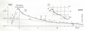
Podélný profil skalním zřícením (a) na svahu Nevados Huascaran v Peru z r. 1970; (b) – profil s. svahem hory Nevados Huascaran; c – suťový kužel nad jezerem Laguna Alta, kde zahynula čs. horolezecká výprava. A – Arma-pampa, V – Vuelta, R – Ranrahirca , Y - Yungay (podle V. Mencla, 1974).
V roce 1972 doprovázel několik manželek zahynulých horolezců do Peru pod Huascaran MUDr. Zdeněk Vlč, expediční lékař několika výprav do jihoamerických And a do Hindúkuše. V televizním pořadu Dobytí kontinentů v dílu Člověk proti horám, v němž jsme společně vystupovali, mi vyprávěl, že původně byla návštěva místa katastrofy slíbena všem manželkám, ale nebyly na to finanční prostředky. Jedna manželka našla mezi balvany v suťovém proudu, pokrývajícím těla horolezců, ponožky, které upletla svému muži na tuto výpravu. Byl to prý pro všechny přítomné velmi silný emocionální zážitek.
Dne 25. května 1975 vystoupila československá horolezecká expedice jako první toho roku na horu Huascaran (6768 m n.m.). Výstup nebyl snadný, neboť teprve v květnu začíná vhodné období pro výstupy na horské velikány, i když příroda i nadále uplatňuje svoje nároky na rozmary. A tak se stalo, že horolezci Ivan Gálfi (42, vedoucí expedice Nanga Parbat), Ivan Fiala (34, vystoupil na Nanga Parbat), Taras Pačok (28) a Vincent Dubeň (35, vedoucí expedice America Latina 1975) museli překonávat četné nebezpečné nástrahy, zapadali do trhlin zavátých metrem čerstvě navátého sněhu, přecházeli nebezpečné lavinové svahy. Není náhodou, že daleko početnější polská výprava výstup vzdala. Za dva týdny po úspěchu našich horolezců zahynul na Huascaranu německý horolezec. Naši horolezci, skromní a stateční muži, vystoupili na tuto horu s vědomím velkých rizik na počest padlých kamarádů. Měl jsem to štěstí, že jsem se mohl spolu s nimi z dosaženého úspěchu v Limě radovat. Bohužel, tohoto výstupu se nezúčastnil kameraman Juraj Weineziller, neboť měl problémy se žlučníkovými kameny. Využil jsem toho a spolu s ním jsme filmovali následky nedávného zemětřesení v Limě.
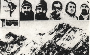
Taras Pačok, Ivan Fiala, Ivan Gálfi, Vincent Dubeň, kameraman Juraj Weineziller. Na počest svých zahynulých kamarádů zdolali jako první expedice roku 1975 vrchol Huascaranu. Propagační fotografie horolezecké expe-dice Latinská Amerika 1975.
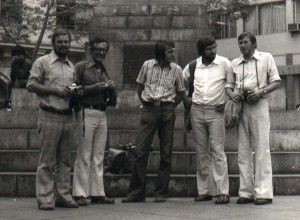
Naše horolezecká expedice v Limě po úspěšném vystoupení na Huascaran. Druhý zleva Ivan Gálfi, uprostřed Ivan Fiala. Foto Otto Horský, 1975.
Se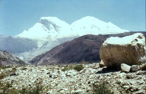 verní vrcholHuascaranu s jasně viditelnou odlučnou hranou, odkud se utrhla lavina skal, ledu a kamení, která zničila město Yungai a obec Ranhahirka.Některé zřícené bloky dosahovaly výšky několikapatrového domu.Foto M. Knejzlík, 1978.
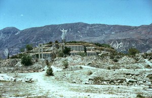
Kristus na hřbitově v Yungai, který byl díky umístění na pahorku před totální zkázou ušetřen.
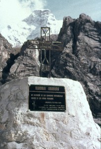
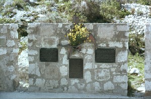
MEMORIAL ANDINISTA.
Památník andinistům. Pro vzpomínku na bratry horolezce zahynulé v peruánských andách. Club Andinista Peruano, Lllanganuco, 31.5.1972.
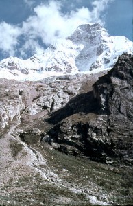
Severní stěna Huascaranu.
Foto M. Knejzlík, 1972.
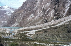
Suťový kužel nad jezerem Laguna Alta, kde zahynula čs. horolezecká výprava. Foto M. Knejzlík, 1978.
.Jihoamerické Andy jsou geologicky mladé, a proto je tu zemětřesení takřka na denním pořádku. Sám jsem se o tom mohl jako geolog během dvouletého pobytu v Peru přesvědčit. Přijel jsem do Limy krátce po katastrofickém zemětřesení v říjnu roku 1974 a mohl jsem takto vidět a studovat jeho následky. Jen v Limě zanechalo 78 mrtvých a 2414 raněných, další desítky obětí byly v širokém okolí dále od jeho epicentra. Nejvíce byly postiženy oblasti města s domy z adobe, z vepřovic, domy zabezpečené proti zemětřesení většinou postiženy nebyly. Můj kolega, bydlící ve 14 poschodí mrakodrapu mi vykládal, že nehorším jeho zážitkem byl kolébavý rozkmit domu, vychylující se do stran až o dva metry.
Lima a okolí podle písemně dochovaných údajů prodělala v každém z minulých století více než jedno silné zemětřesení. V roce 1745 měla pouze 3000 domů, po silném zemětřesení jich zůstalo jen 25. Od té doby se v Peru konají prosebná procesí věřících na uctění památky obětí. V horách však existují nevypočitatelné okolnosti, které většinou vedou k daleko větším tragediím. To však neznamená, že lidé, kteří sem vstupují, se zasvěcují smrti. V případě československé horolezecké expedice tomu však souhrou náhodných okolností opravdu bylo. Po katastrofickém zemětřesení v roce 1970, při němž i oni zahynuli, zřídila peruánská vláda Národní úřad civilní obrany, který, kromě přípravy obyvatelstva, jak se chovat při zemětřesení, vždy s úctou připomíná 31 květen cvičným vyhlášením zemětřesení v celé zemi. Nově vybudované město Yungay je dnes také nazýváno městem mezinárodní solidarity.a bylo zařazeno na listinu světového dědictví.
 Na památníku, který stojí nedaleko místa bývalého základního tábora expedice, je umístěn tento nápis:„V květnu roku 1970 stál u jezera Llanganuco základní tábor československé horolezecké expedice. Při zemětřesení dne 31. 5. 1970 byl zasypán kamennou a sněhovou lavinou z vrcholu Huascaranu. Všichni členové expedice spolu se svým chilským přítelem zahynuli. Vzpomínáme na Vás, kamarádi." Členové výpravy:Arnošt Černík (44), Milan Černý (26), Vilém Heckel (52), Jiří Jech (38), Valerián Karoušek (41), Jaroslav Krecbach (24), Miloš Matras (37), Ladislav Majsner (34), Milan Náhlovský (26), Bohumil Nejedlo (38), Zdeněk Novotný (32), Jiří Rasl (34), Svatopluk Ulvr (32) a Václav Urban (35).
V listopadu 2011, české velvyslanectví v Peru se sídlem v Limě, umístilo na hlavní cestě v okolí Lagunas de Llanganuco dřevěný ukazatel na památník místa neštěstí. Dříve nebylo toto místo nijak označeno a bylo těžké ho najít. K připomenutí památky českých obětí zemětřesení byl lyžařský závod Jizerská padesátka pojmenován Memoriál Expedice Peru.
Na závěr uvádím svědectví dvou přeživších obyvatel města Yungay:
„V horní části města jsem pozoroval blížící se světlešedou gigantickou vlnu bahna a kamení, velmi podobnou přílivové vlně na moři. Hřeben vlny dosahoval výšky 25 až 30 metrů ..“ “Slyšeli jsme ohromný hluk, který se šířil po obou stranách údolí. Ten hluk připomínal řev mnoha letadel. Netušili jsme, odkud přichází, ani co se přihodilo, v těchto okamžicích nás nenapadlo dávat to do spojitosti s Huascaranem. Nakonec jsme spatřili blížící se aluvion složený z černého bahna a kamení vysoký 40 metrů a z něho se metaly a přeskakovaly různě barevné jiskry a ve vzduchu se vznášely obrovské balvany...”
Některé zdroje uvádějí, že v Yungayi bylo pohřbeno pod 7 až 10 metrovou pokrývkou bahna a kamení až 23 000 lidí. Zachránilo se jen asi 300 lidí, kterým se podařilo doběhnout ke hřbitovu na pahorku a několik desítek dětí, které byly právě v cirkuse Berolina výše ve svahu. Lavina pohřbila i svatebčany při právě probíhajícím bujném veselí.
Doslov: Je opravdu potěšitelné, že peruánská strana si velice váží předchozích badatelských aktivit českých odborníků a štafetu převzala mladší generace badatelů, kteří velmi úspěšně rozvíjejí v kooperaci s pracovištěm Národního vodohospodářského úřadu Peru (Autoridad Nacional de Agua – ANA) v Huarazu badatelský projekt, týkající se pohoří Cordillera Blanca. Jde o hodnocení přírodních rizik a nebezpečí sesuvů a povodní z ledovcových jezer ve vybraných ledovcových údolích. Mezi ně patří zejména Dr. Jan Klimeš z Ústavu struktury a mechaniky hornin AV ČR, doc.Vít Vilímek z Katedry fyzické geografie a geoekologie PřF UK a pracovníci Výzkumného ústavu vodohospodářského T.G.Masaryka.
Článek s fotografiemi uveřejněn v časopise Montana, 2015, č. 5, str. 44 - 47.
45 YEARS FROM CATASTROPHY UNDER HUSCARAN
Otto Horský
I'm sitting at the Roma cinema in Lima and watching the unfolding story of the film Earthquake. Suddenly I hear the rage and the elastic wave for the first time shakes the hall. Lovers on the screen do not care about winding the windows and climbing the glass. There was a first wave of excitement throughout the cinema hall, and many who were so familiar with the effects of the earthquake, slid like a command of a chair, crawling on the floor, or running away from the hall. But the movie goes on. Most of the viewers return to their places after a while and try hard to absorb the convincing character of the film's shake. In the film, a geological breakthrough opens in the film, and two geologists measuring the seismic activity disappear. The cinema hall and the people in it are shaking again with the elastic waves that allow the new three-dimensional sound technique. The walls are already vibrating, the spectators are bumping on their chairs, all stiff with unlimited horror. The impression is perfectly perfect, because we are in a country where people have experienced the unfortunate effects of this blooming mankind several times. Thanks to these experienced and impulsive viewers, I experienced a film performance accompanied by authentic demonstrations of crisis behavior. I arrived in Lima at the beginning of December 1974 and the audience still had a vivid memory of the horrors of a recent earthquake that affected the city.
On 31 May 1970, Peru suffered a massive earthquake of 7.5 degrees on the Richter scale. The shocks caused the release of an ice avalanche and stones from the northern wall of Huascaran, which fell 2500 meters below and buried the base camp of a Czechoslovak climbing expedition. All 14 members of the expedition together with the Chilean guide died.
This earthquake of 7 to 9 degrees Richter scale has its immense intensity but also the number of deaths, among the largest recorded earthquakes not only in Peru but throughout the Western Hemisphere. The affected area ranged from the Pacific coast to the Kordiller Range with a length of 1000 km and a width of 250 km, an area of 83,500 km2 was devastated. In total or nearly 250 cities and villages disappeared, about 80,000 people were killed, 20,000 remained missing, another 50,000 were seriously injured, 143,331 injured in hospitals, 200,000 people were left without shelter, some 3 million people. The epicenter of the earthquake was located in the sea 30 km west of the port city of Chimbote. In Chimbote itself, the magnitude of the M to VIII degree earthquake reached the 9th degree in the ancient city of Casma. The force of the earthquake was so great that it caused a range of landslides over a 100 km radius around Chimbote and the Pacific Ocean, but especially in the Ancash Mountain Range and the Huánuco and La Libertad provinces. Almost a third of all victims of the disaster died in the region of the highest Peruvian mountain, Huascaran, from which a powerful avalanche that hit the densely populated areas broke down. Subsequent slope movements were combined here and caused great losses.
The catastrophe did not affect our mountaineering expedition. It was a damp, autumn day, May 31, 1970, similar to every year at this time. In Lima, Peru was overcast, a "garrua" fell on the city, as the inhabitants call it a dense mint, typical for autumn days. The administrative areas of Ancash and La Libertad were resting in a quiet afternoon cool. Somewhere high below the highest Peruvian mountain Huascaran (6768 m above sea level), a 14-year Czechoslovak mountaineer expedition was about to leave. They were all assembled in the base camp, discussing the details and tasks of the individual members of the expedition. And then it happened. It was just 15.36 hours. Nobody expected it. The huge earthquake of the country of intensity VII0 intensity according to the MCS scale lasted 45 seconds. These 45 seconds killed thousands of human lives. Decades of human effort suddenly turned into ruins, and the damage was unprecedented. Of the 38 towns and villages in Ancash 15, it was totally destroyed and the rest was badly damaged. More than 70,000 homes were classified as uninhabitable, water supply, sewerage was destroyed, electricity production was limited to just 10% of normal power at the Cañol del Pato hydroelectric power station on the Santa Huall in Huallanca Province and the hydroelectric power plant was seriously damaged. Without any doubt, this administrative area was most affected, and in particular, the picturesque area of Callejon de Huaylas under Huascaran. The city of Huaraz was covered with a black carpet of dust after the earthquake, leaving 10,000 dead. Also, other towns and villages in this area were totally destroyed, from Recuay in the south to Huallanca in the north. The second most significant city of Yungay, along with the Ranrahirka settlement, was buried beneath the avalanche of mud and stones, under which 25,000 inhabitants remained and the entire Czechoslovak mountaineering expedition. Avalanches and landslides interrupted roads and roads, in several places blocked the flow of the River Santa, and the railroad linking the city of Chimbote with Huallanka disappeared.
Sadly, we remember this tragic natural disaster. It is well known that the northern peak of Huascaran in the White Cordilleras is one of the massifs standing on rigid legs. Already in the past, devastating avalanches of stones and shattered material have collapsed from this mountain and destroyed Ranrahirca. In 1962, four thousand people died in this settlement and in its neighborhood. The North Summit has shown its unease in modern history several times. Perhaps no other mountain in this area so often shakes its massive ice sheet.
"After deafening rumble, a few blocks of rock and ice collapsed, which in the course of their fall would pull away another material and cause large landslides of ice, snow and rocks and pass through the Huayl Gorge," Callejon de Huayalas, "a narrow canyon along the Santa River.
Unfortunately, at the time when Huascaran's camp was camped, Peru was one of the greatest earthquakes in modern history. Such an onslaught could not resist the incoherent Huascaran. After the first major bout, a ninety-foot-thick and two-kilometer-wide block of ice and snow broke down, crashing down an eight-hundred-foot high rock wall. With it, he had carried away an enormous amount of rock blocks and rubble. The avalanche flew through one of the glaciers, rummaged through the lateral moraines, and pushed down into Rio Shacsha Canyon. The flush had such a kinetic energy that at the upper end of the canyon the side of the canyon crossed the mountain ridge as if it had been catapulted and then slid down to the city of Yungay. The main stream of the avalanche was sweeping down the valley of the Shacsha River, sweeping Ranrahirka, and then rolling down the valley of the Santa River, where it completed the work of destruction throughout the flow. The idea of how exceptional a landslide might have contributed to the fact that up to the Shacsha Valley continued to bring rock blocks as large as a block of flats. The speed of the landslide was in line with physical laws. It is fifteen kilometers from the point of mass breaking to the confluence of the rivers. The main mass of the landslide tripped this distance in about two minutes, which corresponds to a speed of up to 450 kilometers per hour. Of course, at such a speed, it had the devastating effect of a still compressed air cushion in front of an avalanche whose volume is estimated at fifty million cubic meters of matter. Under the huge mass of snow, ice, mud and stones, fourteen Czechoslovak mountaineers found death. The city of Yungay ceased to exist.
Recalling this event, the question arises as to whether our climbers have correctly chosen their base in which they were preparing to exit. Definitely yes. Indeed, its location was consulted with Peruvian Andinists and other experts. But who could expect the mass of Huascaran to be so huge and alive that it would roll over the valley and over the opposite ridge and fill our climbers? About two kilometers up the hillside was the camp of Japanese climbers who watched the tragedy and the avalanche was gone.
After the earthquake, the Peruvian government invited a number of internationally recognized experts to assess the disaster. Among them, one of the world's most respected experts in the field of rock mechanics, Professor Vojtech Mencla of the Technical University in Brno. He considered the causes of the origin and the nature of the landslide. According to him, the western part of the summit of Mount Nevados Huascaran collapsed to the glacier, creating a tremendous avalanche of stones, snow and ledu, which created a 16m long debris, with masses of 50-100 million cubic meters. The speed of the rock scree was estimated at 280 km / h, more or less. Part of the movement was done over the air cushion (Mencl 1974). In the Valley of the River Santas, this material was mixed with water, and motion continued as a typical scrub stream.
The longitudinal profile of the rock collapsed (a) on the slope of Nevados Huascaran in Peru from 1970; (b) - profile with the slope of Mount Nevados Huascaran; c - Fallow cone over Lake Laguna Alta, where the Czechoslovakia perished. climbing trip. A - Arma - Pampa, V - Vuelta, R - Ranrahirca, Y - Yungay (according to V. Mencla, 1974).
In 1972 he accompanied several wives of dead climbers to Peru under Huascaran MUDr. Zdeněk Vlč, expeditionist of several expeditions to South American And to Hindukush. In the TV Conquest of the Continents program in The Man Against the Mountains, in which we performed together, he told me that the visit to the disaster was originally promised to all the wives, but they were not money. One of the women found between the boulders in the cloud stream that covered the bodies of the climbers, the socks she had tied to her husband on this mission. It was a very strong emotional experience for all of us.
On May 25, 1975, the Czechoslovak mountaineering expedition first appeared on Mount Huascaran (6768 m above sea level). It was not easy to get out, as it was only in May that a suitable period for climbing to mountain giants began, even though nature continued to claim its quirks. And so it happened that climbers Ivan Gálfi (42, expedition manager Nanga Parbat), Ivan Fiala (34, Nanga Parbat), Taras Pačok (28) and Vincent Dubeň (35, head of the America Latin 1975 Expedition) had to overcome numerous dangerous traps, fallen into the cracks thrown by the underground snow of fresh snow, passing dangerous avalanche slopes. It is no coincidence that the far bigger Polish expedition gave up. In two weeks after the success of our climbers, a German climber killed Huascaran. Our mountaineers, modest and brave men, stepped up to this mountain, aware of great risks in honor of fallen comrades. I was lucky to be able to rejoice with them from their success in Lima. Unfortunately, cameraman Juraj Weineziller did not attend this show because he had problems with gallstones. I used this and together with him we filmed the consequences of the recent earthquake in Lima.
Taras Pačok, Ivan Fiala, Ivan Gálfi, Vincent Dubeň, cameraman Juraj Weineziller. In honor of their dead comrades, Huascaran peaked as the first expedition in 1975. Promotional photo of the mountain climbing excursion Latin America 1975.
Our climbing expedition in Lima after a successful performance at Huascaran. Second left Ivan Gálfi, in the middle of Ivan Fial. Photo by Otto Horský, 1975.
Left: MEMORIAL ANDINIST, Memorial to the Andinists. For the memory of the climbing brothers killed in the Peruvian Andes. Club Andino Peruano, Llanganuco, May 31, 1972. Right: The Christ at the Yungay Cemetery, which was spared by its place on the hill before total destruction. The four top images show the total destruction of Yungay, some of the relocated blocks reaching the size of a multi-storey house. Photo by M. Knejzlík, 1978.
Fallow cone over Laguna Alta Lake, where MS died. climbing trip. Photo by M. Knejzlík, 1978.
The South American Andes are geologically young, and that's why the earthquake is almost on a daily basis. I myself have been able to convincing myself as a geologist during a two-year stay in Peru. I arrived in Lima shortly after the catastrophic earthquake in October 1974 and I could see and study its consequences. Only in Lima left 78 dead and 2414 wounded, the next dozens of victims were in a wide area away from his epicenter. Most affected areas of the city with homes from adobe, from pigs, houses secured against earthquakes were mostly not affected. My colleague, living on the 14th floor of a skyscraper, told me that I did not hurt his experience with the creeping frenzy of the house, swinging to the sides for as much as two meters.
Lima and its surrounding area, according to written data, has experienced more than one strong earthquake in each of the past centuries. In 1745, it had only 3,000 houses, after a strong earthquake, only 25 remained. Since then, Peru's apostolic procession has been held to honor the memorial of the victims. In the mountains, however, there are unpredictable circumstances, which usually lead to far greater tragedies. This does not mean, however, that the people who enter here are initiating death. In the case of the Czechoslovak mountaineering expedition, however, it was really a coincidence of random circumstances. After the catastrophic earthquake in 1970, when they perished, the Peruvian government set up the National Civil Defense Bureau, which, in addition to preparing the population to behave in an earthquake, always remembers 31 May as an earthquake proclamation throughout the country. The newly built city of Yungay is now also called the city of international solidarity. It has been listed as a World Heritage Site.
At the memorial, which stands near the site of the former base camp of the expedition, the following inscription is placed: "In May 1970, he stood at the Llanganuco Lake, the base camp of the Czechoslovak climbing expedition. During the earthquake on May 31, 1970, it was covered with a stone and snow avalanche from the summit of Huascaran. All expedition members and their Chilean boyfriend were killed. We are reminded of you, my friends. "Arnošt Cernik (44), Milan Cerny (26), Vilém Heckel (52), Jiří Jech (38), Valerián Karoušek (41), Jaroslav Krecbach ), Ladislav Majsner (34), Milan Náhlovsky (26), Bohumil Nejedlo (38), Zdeněk Novotný (32), Jiří Rasl (34), Svatopluk Ulvr (32) and Václav Urban (35).
In November 2011, the Embassy of Peru, based in Lima, placed a wooden pointer at the memorial site of the misfortune on the main road in Lagunas de Llanganuco. Previously, this place was not marked and was hard to find. To commemorate the Czech victims of the earthquake, the Jizerské 50s Ski Resort was named the Expedition Memorial of Peru.
Finally, I present the testimony of the two surviving inhabitants of Yungay:
"At the top of the city I watched the approaching light gray gigantic wave of mud and stones, a very similar tidal wave at sea. The crest of the wave was 25 to 30 meters high. "
"We heard the tremendous noise that spread across both sides of the valley. The noise echoed the roar of many planes. We did not know where it came from, or what happened, at these times, we did not think of putting it in touch with Huascaran. Finally, we saw the approaching alluvium, composed of black mud and stones, 40 meters tall, and blooming with different sparks, and huge boulders floating in the air ... "
Some sources report that Yungay was buried under 7 to 10 meters of mud and stones covering up to 23,000 people. Only about 300 people managed to reach the cemetery on the hill, and dozens of children who were in the Berolina circus higher up the slope. The avalanche buried weddings in the lively glee.
It is really gratifying that the Peruvian party is very much in favor of the previous research activities of Czech experts and the relay was taken over by younger generations of researchers who have very successfully developed a research project in cooperation with the work of the National Authority of Peru (ANA) in Huaraz the Cordillera Blanca Mountains. This is an assessment of natural hazards and the risk of landslides and glacier lakes floods in selected glacial valleys. These include, in particular, Dr. Jan Klimeš from the Institute of Structure and Mechanics of Rocks of the Academy of Sciences of the Czech Republic, doc.Vit Vilímek from the Department of Physical Geography and Geoecology of the Faculty of Science, and the staff of the Water Management Research Institute T.G.Masaryka.
A photograph and article published in Montana, 2015, No. 5, pp. 44-47.

